- HomeElectronicsPortable Audio & VideoMP3 & MP4 Player AccessoriesBluetooth & FM TransmittersFM Transmitters
Description
CMOR Mapping's game-changing, high-resolution bathymetric imagery for Simrad, Lowrance, B&G, and Raymarine chart plotters and Mercury Vessel View displays brings the ocean floor into an entirely new level of focus for anglers and divers. CMOR Mapping data comes from methodical surveys of the entire bottom with high-resolution echo sounders -- not point soundings and historical records. With resolution as high as 1 meter -- meaning each pixel equals a square meter of bottom -- you see every ledge, coral head, and sunken culvert in unprecedented detail. Just insert a CMOR Mapping card into your plotter and zoom in to see bathymetric imagery. Your vessel icon shows your exact location relative to bottom features.
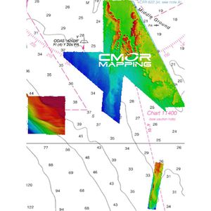
CMOR Mapping MDGR001S High-Resolution Bathymetric Cartography for Simrad/B&G Units, Florida Middle Grounds
Current Price
$658.27
Average
$601.89
Min Price
$472.9
Max Price
$700
Price dynamics
9%
Description
CMOR Mapping's game-changing, high-resolution bathymetric imagery for Simrad, Lowrance, B&G, and Raymarine chart plotters and Mercury Vessel View displays brings the ocean floor into an entirely new level of focus for anglers and divers. CMOR Mapping data comes from methodical surveys of the entire bottom with high-resolution echo sounders -- not point soundings and historical records. With resolution as high as 1 meter -- meaning each pixel equals a square meter of bottom -- you see every ledge, coral head, and sunken culvert in unprecedented detail. Just insert a CMOR Mapping card into your plotter and zoom in to see bathymetric imagery. Your vessel icon shows your exact location relative to bottom features.
Price will be lower
in next 2 weeks
in next 2 weeks
According to the data, price will be lower in next two weeks, so not waste your money and track better price!
Similar products
