Description
MAX-N+ NA-Y940 - Cape Cod, Long Island & Hudson RiverMAX-N+ brings all the popular C-MAP 4D features to the the Navico family ofchartplotters, including: Detailed Harbor Charts, Dynamic RasterCharts,High-Resolution Satellite Imagery, Custom Shaded Depths, DynamicTides & Currents, High-Resolution Bathymetric Data, Sport Fishing Data,Aerial Photos, C-Marina Port Info & Multi-Language Charts.C-MAP MAX-N+ brings trusted Jeppesen data and advanced charting features tousers of compatible Lowrance, Simrad and B&G navigation systems.Whether you're an avid saltwater angler, sailing enthusiast or long-rangecruiser, these powerful charts will enhance every moment you spend on thewater. With huge coverage areas, up-to-date data and state-of-the-artfeatures, no adventure is out of reach.Software Requirements:Simrad NSO evo2 - Software Version 4.0Simrad NSS evo2 - Software Version 3.0B&G Zeus2 - Software Version 3.0Lowrance HDS Gen2 - Software Version 4.0Lowrance HDS Gen2 Touch - Software Version 4.5Lowrance HDS Gen3 - Software Version 2.0Features:Dynamic Raster Charts - Give sailors a traditional "nautical chart"view with the ability to access important information. High-ResolutionBathymetric (HRB) charts and Sportfishing Data deliver powerful technologyfor avid anglers. Tides & Currents projections help both sailors and anglersplan their dayFull-Featured Vector Charts - Provide boaters with the accurate,up-to-date vector chart detail including Depth Areas and Contours, SpotSoundings, NavAids, Light Sectors, Wrecks/Obstructions, Small CraftFacilities and moreHarbor & Approach Details - Lets boaters approach any harbor and inletwith confidence - the perfect conclusion to a long voyage, sailing adventureor exciting day of blu
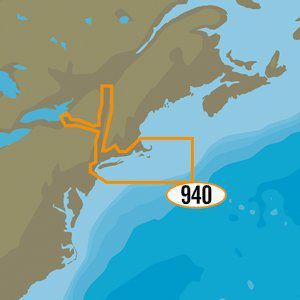
C-MAP MAX-N+ NA-Y940 - Cape Cod, Long Island & Hudson River [NA-Y940]
Price is below average
Current Price
$193.39
Average
$193.72
Min Price
$176.6
Max Price
$311.19
Price dynamics
0%
Description
MAX-N+ NA-Y940 - Cape Cod, Long Island & Hudson RiverMAX-N+ brings all the popular C-MAP 4D features to the the Navico family ofchartplotters, including: Detailed Harbor Charts, Dynamic RasterCharts,High-Resolution Satellite Imagery, Custom Shaded Depths, DynamicTides & Currents, High-Resolution Bathymetric Data, Sport Fishing Data,Aerial Photos, C-Marina Port Info & Multi-Language Charts.C-MAP MAX-N+ brings trusted Jeppesen data and advanced charting features tousers of compatible Lowrance, Simrad and B&G navigation systems.Whether you're an avid saltwater angler, sailing enthusiast or long-rangecruiser, these powerful charts will enhance every moment you spend on thewater. With huge coverage areas, up-to-date data and state-of-the-artfeatures, no adventure is out of reach.Software Requirements:Simrad NSO evo2 - Software Version 4.0Simrad NSS evo2 - Software Version 3.0B&G Zeus2 - Software Version 3.0Lowrance HDS Gen2 - Software Version 4.0Lowrance HDS Gen2 Touch - Software Version 4.5Lowrance HDS Gen3 - Software Version 2.0Features:Dynamic Raster Charts - Give sailors a traditional "nautical chart"view with the ability to access important information. High-ResolutionBathymetric (HRB) charts and Sportfishing Data deliver powerful technologyfor avid anglers. Tides & Currents projections help both sailors and anglersplan their dayFull-Featured Vector Charts - Provide boaters with the accurate,up-to-date vector chart detail including Depth Areas and Contours, SpotSoundings, NavAids, Light Sectors, Wrecks/Obstructions, Small CraftFacilities and moreHarbor & Approach Details - Lets boaters approach any harbor and inletwith confidence - the perfect conclusion to a long voyage, sailing adventureor exciting day of blu
Price will be lower
in next 2 weeks
in next 2 weeks
According to the data, price will be lower in next two weeks, so not waste your money and track better price!
Product review & video
Oh need some fish mate yeah now you'd like to this is how big I am I have what so we are down here in Central Florida and I'm hanging out with my good buddy from Alabama what's up guys mr. canler and so canler's been kinda like bugging in my ear dude he's like man you fish all this deep stuff you need to look at the seed map and I'm like that whatever dude I got Navionics I'm good to go you know like I can see contours whatever and he's like now dude I mean you tell them no it's uh so that's that's right you've been using Navionics for forever right and it's been kind of the gold standards what everybody uses well you know we're coming in we're changing the game this is this is see map and we've come in we're going to show you a little bit here what we've got but it's not what you're used to it's definitely not not your standard detail we're taking detail to a whole new level we've had


Similar products