Description
Garmin BlueChart® g2 HD - HXSA001R - South America East Coast - microSD™/SD™Coverage of the east coast of South America from the Golfo de Paria to Tierra del Fuego. Coverage includes Trinidad and Tobago; the Lago de Brasilia; the Rio de la Plata; the Rio Uruguay to Salto, Uruguay; the Rio Parana to Parana, Argentina and the Falkland Islands (Islas Malvinas).Our Advanced Chart OfferingDerived from official charts and private sources to provide navigational aids, spot soundings, depth contours, tides and currents, and detailed harbors and marinasDepth Range Shading for up to 10 depth ranges enables you to view your target depth at a glanceUp to 1-foot contours provide a more accurate depiction of the bottom structure for improved fishing charts and navigation in swamps, canals and marinasShallow Water Shading feature allows for depth shading at a user-defined level to aid in navigationAdvanced Chart DetailDetailed charts help the mariner guide their boat in and out of port with confidence.Depth Range ShadingDisplays high-resolution Depth Range Shading for up to 10 depth ranges so you can view your designated target depth.Detailed ContoursBlueChart g2 HD features 1-foot contours that provide a more accurate depiction of bottom structure for improved fishing charts and enhanced detail in swamps, canals and port plans. WARNING: This product can expose you to chemicals which are known to the State of California to cause cancer, birth defects or other reproductive harm. For more information go to P65Warnings.ca.gov.
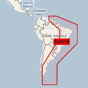
Garmin BlueChart g2 - HXSA001R - South America East Coast - microSDTM/SDTM (41207)
Price is below average
Current Price
$135.1
Average
$139.28
Min Price
$133.73
Max Price
$173.66
Price dynamics
3%
Description
Garmin BlueChart® g2 HD - HXSA001R - South America East Coast - microSD™/SD™Coverage of the east coast of South America from the Golfo de Paria to Tierra del Fuego. Coverage includes Trinidad and Tobago; the Lago de Brasilia; the Rio de la Plata; the Rio Uruguay to Salto, Uruguay; the Rio Parana to Parana, Argentina and the Falkland Islands (Islas Malvinas).Our Advanced Chart OfferingDerived from official charts and private sources to provide navigational aids, spot soundings, depth contours, tides and currents, and detailed harbors and marinasDepth Range Shading for up to 10 depth ranges enables you to view your target depth at a glanceUp to 1-foot contours provide a more accurate depiction of the bottom structure for improved fishing charts and navigation in swamps, canals and marinasShallow Water Shading feature allows for depth shading at a user-defined level to aid in navigationAdvanced Chart DetailDetailed charts help the mariner guide their boat in and out of port with confidence.Depth Range ShadingDisplays high-resolution Depth Range Shading for up to 10 depth ranges so you can view your designated target depth.Detailed ContoursBlueChart g2 HD features 1-foot contours that provide a more accurate depiction of bottom structure for improved fishing charts and enhanced detail in swamps, canals and port plans. WARNING: This product can expose you to chemicals which are known to the State of California to cause cancer, birth defects or other reproductive harm. For more information go to P65Warnings.ca.gov.
Price will be lower
in next 2 weeks
in next 2 weeks
According to the data, price will be lower in next two weeks, so not waste your money and track better price!
Product review & video
what's up guys worked in here holy moly outdoors I'm so excited to join today in this episode because this has been a long going to do list for me and I finally got the parts in and I'm really excited to showcase to you so what we're talking about today I think is truly a crucial upgrade for guys's fish finder that should be there if you're doing any kind of saltwater work so my boat is a 1977 fiber form 16 foot it's a little nice boat that does pretty much all you need to do in Puget Sound for salmon and bottom finish fishing but what it didn't have and it's been a lesson learned but it doesn't have the best GPS plotter it has a big giant Lorant screen it's really nice for the actual fish finder part you know the be able sonar however the map lacks and what it lacks majorly is contour lines so we're going to go through today a little upgrade that I'm doing on a fish finder that I've ma


Similar products